
Book – Echappées artistiques
Artist France Schmid is fascinated by our iconic alpine landscapes and has spent the past 30 years exploring their craggy beauty in a variety of mediums. Her published book, Le Val d'Illiez -...
Artist France Schmid is fascinated by our iconic alpine landscapes and has spent the past 30 years exploring their craggy beauty in a variety of mediums. Her published book, Le Val d’Illiez – Echappées Artistiques is part historical oeuvre, part rambling guide and 100% a stunning art book. This lovely, soft cover book showcases 39 itineraries, illustrated in watercolour and accompanied by a brief description of the hike, plus important place names, historical tidbits, and meaningful quotes by famous authors to set the tone.

Slides - Raclette World Championships
Black sides with logo CMDR on the front. Combined with our CMDR socks, get the perfect look to eat a raclette.
Available sizes:
S = shoe size 38-39
M = shoe size 40-41
L = shoe size 42-43
XL...
Black sides with logo CMDR on the front. Combined with our CMDR socks, get the perfect look to eat a raclette.
Available sizes:
- S = shoe size 38-39
- M = shoe size 40-41
- L = shoe size 42-43
- XL = shoe size 44-45

Bob - Raclette World Championships
A reversible bob: black with the CMDR logo on the front or yellow with our favourite pictograms. A timeless companion for your summer outings. Don't forget your speed goggles!
Product created...
A reversible bob: black with the CMDR logo on the front or yellow with our favourite pictograms. A timeless companion for your summer outings. Don't forget your speed goggles!
Product created in collaboration with our partner Texorio.

Book - La Vallée d'Illiez
Discover the Illiez Valley, its stories, plants, and traditions told through fourteen hikes.

Book - 13 étoiles au sommet – par Gérard Sermier
Relive the ambitious project for the Valais' bicentennial celebration in which thirteen iconic Valais peaks were simultaneously illuminated. Behind the scenes, seventy guides and pyrotechnical...
Relive the ambitious project for the Valais’ bicentennial celebration in which thirteen iconic Valais peaks were simultaneously illuminated. Behind the scenes, seventy guides and pyrotechnical experts, as well as thirty photographers put in 18 months of work so that March 2015 would go up in an unforgettable flame of glory!

Book - Champéry d'autrefois
Relive Champéry’s past events, local traditions, village activities, and picturesque places through this collection of antique photos and accompanying historical anecdotes.

Book - Champéry, Eté 1863
Champéry's past comes to life, illustrated by Bernard Cosendey, pen name Cosey, and imagined by Fabrice Clément. This striking graphic novel tells the story of a mysterious character who ...
Champéry’s past comes to life, illustrated by Bernard Cosendey, pen name Cosey, and imagined by Fabrice Clément. This striking graphic novel tells the story of a mysterious character who stayed at the glamorous Dents du Midi hotel in 1863, at the same time as the Défago Gallery was being carved out of a nearby cliff face ...

Book - Champéry, la Route du Grand-Paradis – par Christian Menu et Philippe Ruault
This beautiful coffee table book showcases the Val d'Illiez's magnificent chalets and emblematic architecture. Its pages safeguard the treasures of a shared heritage written in stone and wood...
This beautiful coffee table book showcases the Val d’Illiez’s magnificent chalets and emblematic architecture. Its pages safeguard the treasures of a shared heritage written in stone and wood and passed down through the generations for everyone to enjoy.

Book - Images d'Antan de la Vau-de-Lie
This collection of stories, events, artifacts, and anecdotes delve into the past of Champéry and the Val d'Illiez, from prehistory to today.

Book - La vie à Champéry par Mars
Maurice de Bonvoisin (1849-1912), pen name Mars, was a renowned illustrator of picturesque characters and village scenes from the beginning of the 20th century. The charming sketches and witty...
Maurice de Bonvoisin (1849-1912), pen name Mars, was a renowned illustrator of picturesque characters and village scenes from the beginning of the 20th century. The charming sketches and witty commentary found in ‘La Vie à Champéry’ bring the olden days to life!
Available in French.

Book - Les Portes du Soleil, des Cimes et des Hommes
Anlässlich seines 60-jährigen Jubiläums (gefeiert im Jahr 2024) feiert das französisch-schweizerische Skigebiet Portes du Soleil seine Geschichte, Landschaften sowie die leidenschaftlichen...
Anlässlich seines 60-jährigen Jubiläums (gefeiert im Jahr 2024) feiert das französisch-schweizerische Skigebiet Portes du Soleil seine Geschichte, Landschaften sowie die leidenschaftlichen Frauen und Männer, die es geprägt haben, mit einem außergewöhnlichen Bildband von 144 Seiten.
Als Ergebnis einer bewegenden Erinnerungsarbeit zeichnet dieses schöne Buch 60 Jahre menschliches Abenteuer, sportliche Herausforderungen und alpine Zusammenarbeit nach. Mit Archivaufnahmen und aktuellen Fotos illustriert, bietet es einen einzigartigen Blick auf eines der größten Skigebiete der Welt.

Book - L’industrie des étrangers
Originally written as a thesis for a history degree and published in the series 'Les Cahiers de l'Histoire Locale', this work is an in-depth study of the birth of tourism in the Val d'Illiez,...
Originally written as a thesis for a history degree and published in the series ‘Les Cahiers de l'Histoire Locale’, this work is an in-depth study of the birth of tourism in the Val d’Illiez, and its development up to the days before WWII.

Book - Tour des Dents du Midi et Tour des Dents Blanches
Visible from near and far, the iconic Dents du Midi massif just begs to be explored. This historic, multi-day trek is the perfect introduction to long-distance hiking. The Tour des Dents ...
Visible from near and far, the iconic Dents du Midi massif just begs to be explored. This historic, multi-day trek is the perfect introduction to long-distance hiking. The Tour des Dents Blanches is more challenging, with starker, more exposed itineraries that leapfrog over the border between Switzerland and France in full view of the Mont Blanc massif.

Book - Valais, ton empreinte – par Roger Rudaz
This magnificent collection of poetry is an ode to Valais winegrowers, vineyards, and wine.

Book - Voyage dans le passé de Champéry – par la Fondation du Patrimoine Champérolain
This little pamphlet explores Champéry’s bygone days, from tourism to domestic life, the economy, politics, and emigration.
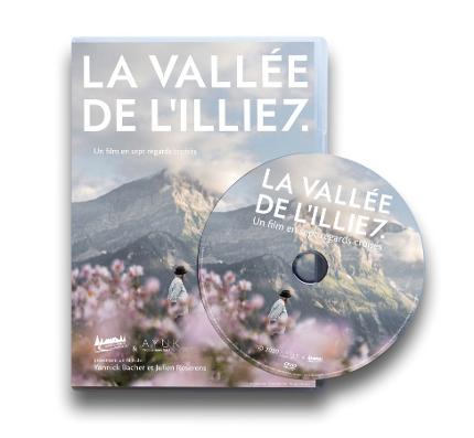
DVD - La Vallée de l'Illiez
The Vallée de l'Illiez is a feature-length documentary set in the Illiez Valley, located in the Canton of Valais, Switzerland. Inspired by the seven craggy peaks of the iconic Dents du Midi...
The Vallée de l'Illiez is a feature-length documentary set in the Illiez Valley, located in the Canton of Valais, Switzerland.
Inspired by the seven craggy peaks of the iconic Dents du Midi mountain range which stands guard over the valley, the film immerses itself in the daily lives of seven of its inhabitants. The characters, each very different from the other, tell their own story with the generosity and authenticity so characteristic to this region, offering up their unvarnished truths, as beautiful or brutal as they may be. Captured on film, the deceptively simple images and words plumb unsuspected depths, shedding light on geographic, environmental, and economic specificities of the valley, as well as its vast potential and future challenges.
Documentary film • 72 ’• French • 2019-2020 • Val-d´Illiez, Switzerland

Dents Du Midi thermo flask
Hiking, mountain biking, snowshoeing... whatever the activity, stay hydrated with our Dents du Midi thermo flask (0.5 litre)!
Made from high-quality stainless steel, it keeps your coffee or tea...
Hiking, mountain biking, snowshoeing... whatever the activity, stay hydrated with our Dents du Midi thermo flask (0.5 litre)!
Made from high-quality stainless steel, it keeps your coffee or tea hot for hours. In summer, it will keep your drinks cool throughout your adventure.
Moreover, every stop will be an opportunity to (re)discover the names of the Dents du Midi, elegantly engraved on the flask.
Keeps hot: 8 hours
Keeps cold: 16 hours
Material: stainless steel
Capacity: 500ml
Colour: khaki
Product created in collaboration with our partner Texorio.

Duffle bag
The Région Dents du Midi duffle bag will be your ideal companion for your mountain holidays! With a capacity of 35 L, this practical backpack features numerous pockets, including a shoe...
The Région Dents du Midi duffle bag will be your ideal companion for your mountain holidays! With a capacity of 35 L, this practical backpack features numerous pockets, including a shoe compartment that protects the rest of your belongings, and can be carried either on your back or by hand.
Brand: V8 équipement
Bag dimensions: 53 x 33 x 21 cm (Can be used as carry-on luggage on planes)
Materials: 3D Mesh/900D Polyester/PU

Bottle cooler - Raclette World Championships
Wooden wine bottle cooler with CMDR engraving. Keep your white wine cool throughout the raclette!

Pepper mill - Raclette World Championships
Elegant, functional wooden pepper mill with CMDR engraving. Add the right amount of pepper to your raclette.
Product created in collaboration with our partner Texorio.


Poster Danny Touw - Champoussin / Large format
Dimensions: 50 x 70 cm.
Danny Touw hails from the Netherlands, but his works draw inspiration from the spectacular alpine landscapes that surround his adopted home, here at the foot of the...
Dimensions: 50 x 70 cm.
Danny Touw hails from the Netherlands, but his works draw inspiration from the spectacular alpine landscapes that surround his adopted home, here at the foot of the Dents du Midi in Champéry, Switzerland. Actively involved in promoting art throughout the region, he notably founded the immensely popular Art Champéry live auction.
Region Dents du Midi is proud to present a limited series of posters, created especially by Danny Touw to showcase some of our most breathtaking landscapes. Printed on premium-quality art paper, the posters are available in two sizes: 30×40 cm et 50×70 cm.

Poster Danny Touw - Champéry - Cable car / Large format
Dimensions: 50 x 70 cm.
Danny Touw hails from the Netherlands, but his works draw inspiration from the spectacular alpine landscapes that surround his adopted home, here at the foot of the...
Dimensions: 50 x 70 cm.
Danny Touw hails from the Netherlands, but his works draw inspiration from the spectacular alpine landscapes that surround his adopted home, here at the foot of the Dents du Midi in Champéry, Switzerland. Actively involved in promoting art throughout the region, he notably founded the immensely popular Art Champéry live auction.
Region Dents du Midi is proud to present a limited series of posters, created especially by Danny Touw to showcase some of our most breathtaking landscapes. Printed on premium-quality art paper, the posters are available in two sizes: 30×40 cm et 50×70 cm.

Poster Danny Touw - Champéry - Cable car / Small format
Dimensions: 30 x 40 cm.
Danny Touw hails from the Netherlands, but his works draw inspiration from the spectacular alpine landscapes that surround his adopted home, here at the foot of the...
Dimensions: 30 x 40 cm.
Danny Touw hails from the Netherlands, but his works draw inspiration from the spectacular alpine landscapes that surround his adopted home, here at the foot of the Dents du Midi in Champéry, Switzerland. Actively involved in promoting art throughout the region, he notably founded the immensely popular Art Champéry live auction.
Region Dents du Midi is proud to present a limited series of posters, created especially by Danny Touw to showcase some of our most breathtaking landscapes. Printed on premium-quality art paper, the posters are available in two sizes: 30×40 cm et 50×70 cm.

Poster Danny Touw - Champéry - Chair lift / Large format
Dimensions: 50 x 70 cm.
Danny Touw hails from the Netherlands, but his works draw inspiration from the spectacular alpine landscapes that surround his adopted home, here at the foot of the...
Dimensions: 50 x 70 cm.
Danny Touw hails from the Netherlands, but his works draw inspiration from the spectacular alpine landscapes that surround his adopted home, here at the foot of the Dents du Midi in Champéry, Switzerland. Actively involved in promoting art throughout the region, he notably founded the immensely popular Art Champéry live auction.
Region Dents du Midi is proud to present a limited series of posters, created especially by Danny Touw to showcase some of our most breathtaking landscapes. Printed on premium-quality art paper, the posters are available in two sizes: 30×40 cm et 50×70 cm.

Poster Danny Touw - Champéry - Chair lift / Small format
Dimensions: 30 x 40 cm.
Danny Touw hails from the Netherlands, but his works draw inspiration from the spectacular alpine landscapes that surround his adopted home, here at the foot of the...
Dimensions: 30 x 40 cm.
Danny Touw hails from the Netherlands, but his works draw inspiration from the spectacular alpine landscapes that surround his adopted home, here at the foot of the Dents du Midi in Champéry, Switzerland. Actively involved in promoting art throughout the region, he notably founded the immensely popular Art Champéry live auction.
Region Dents du Midi is proud to present a limited series of posters, created especially by Danny Touw to showcase some of our most breathtaking landscapes. Printed on premium-quality art paper, the posters are available in two sizes: 30×40 cm et 50×70 cm.

Poster Danny Touw - Les Crosets / Large format
Dimensions: 50 x 70 cm.
Danny Touw hails from the Netherlands, but his works draw inspiration from the spectacular alpine landscapes that surround his adopted home, here at the foot of the...
Dimensions: 50 x 70 cm.
Danny Touw hails from the Netherlands, but his works draw inspiration from the spectacular alpine landscapes that surround his adopted home, here at the foot of the Dents du Midi in Champéry, Switzerland. Actively involved in promoting art throughout the region, he notably founded the immensely popular Art Champéry live auction.
Region Dents du Midi is proud to present a limited series of posters, created especially by Danny Touw to showcase some of our most breathtaking landscapes. Printed on premium-quality art paper, the posters are available in two sizes: 30×40 cm et 50×70 cm.

Poster Danny Touw - Les Crosets / Small format
Dimensions: 30 x 40 cm.
Danny Touw hails from the Netherlands, but his works draw inspiration from the spectacular alpine landscapes that surround his adopted home, here at the foot of the...
Dimensions: 30 x 40 cm.
Danny Touw hails from the Netherlands, but his works draw inspiration from the spectacular alpine landscapes that surround his adopted home, here at the foot of the Dents du Midi in Champéry, Switzerland. Actively involved in promoting art throughout the region, he notably founded the immensely popular Art Champéry live auction.
Region Dents du Midi is proud to present a limited series of posters, created especially by Danny Touw to showcase some of our most breathtaking landscapes. Printed on premium-quality art paper, the posters are available in two sizes: 30×40 cm et 50×70 cm.

Poster Danny Touw - Morgins / Large format
Dimensions: 50 x 70 cm.
Danny Touw hails from the Netherlands, but his works draw inspiration from the spectacular alpine landscapes that surround his adopted home, here at the foot of the...
Dimensions: 50 x 70 cm.
Danny Touw hails from the Netherlands, but his works draw inspiration from the spectacular alpine landscapes that surround his adopted home, here at the foot of the Dents du Midi in Champéry, Switzerland. Actively involved in promoting art throughout the region, he notably founded the immensely popular Art Champéry live auction.
Region Dents du Midi is proud to present a limited series of posters, created especially by Danny Touw to showcase some of our most breathtaking landscapes. Printed on premium-quality art paper, the posters are available in two sizes: 30×40 cm et 50×70 cm.

Poster Danny Touw - Morgins / Small format
Dimensions: 30 x 40 cm.
Danny Touw hails from the Netherlands, but his works draw inspiration from the spectacular alpine landscapes that surround his adopted home, here at the foot of the...
Dimensions: 30 x 40 cm.
Danny Touw hails from the Netherlands, but his works draw inspiration from the spectacular alpine landscapes that surround his adopted home, here at the foot of the Dents du Midi in Champéry, Switzerland. Actively involved in promoting art throughout the region, he notably founded the immensely popular Art Champéry live auction.
Region Dents du Midi is proud to present a limited series of posters, created especially by Danny Touw to showcase some of our most breathtaking landscapes. Printed on premium-quality art paper, the posters are available in two sizes: 30×40 cm et 50×70 cm.

Poster Danny Touw - Region Dents du Midi / Large format
Dimensions: 50 x 70 cm.
Danny Touw hails from the Netherlands, but his works draw inspiration from the spectacular alpine landscapes that surround his adopted home, here at the foot of the...
Dimensions: 50 x 70 cm.
Danny Touw hails from the Netherlands, but his works draw inspiration from the spectacular alpine landscapes that surround his adopted home, here at the foot of the Dents du Midi in Champéry, Switzerland. Actively involved in promoting art throughout the region, he notably founded the immensely popular Art Champéry live auction.
Region Dents du Midi is proud to present a limited series of posters, created especially by Danny Touw to showcase some of our most breathtaking landscapes. Printed on premium-quality art paper, the posters are available in two sizes: 30×40 cm et 50×70 cm.

Poster Danny Touw - Region Dents du Midi / Small format
Dimensions: 30 x 40 cm.
Danny Touw hails from the Netherlands, but his works draw inspiration from the spectacular alpine landscapes that surround his adopted home, here at the foot of the...
Dimensions: 30 x 40 cm.
Danny Touw hails from the Netherlands, but his works draw inspiration from the spectacular alpine landscapes that surround his adopted home, here at the foot of the Dents du Midi in Champéry, Switzerland. Actively involved in promoting art throughout the region, he notably founded the immensely popular Art Champéry live auction.
Region Dents du Midi is proud to present a limited series of posters, created especially by Danny Touw to showcase some of our most breathtaking landscapes. Printed on premium-quality art paper, the posters are available in two sizes: 30×40 cm et 50×70 cm.

Postcard Champéry – Bell-tower and cable car
Dimensions: 14.8 x 10.5 cm (A6).
Danny Touw hails from the Netherlands, but his works draw inspiration from the spectacular alpine landscapes that surround his adopted home, here at the...
Dimensions: 14.8 x 10.5 cm (A6).
Danny Touw hails from the Netherlands, but his works draw inspiration from the spectacular alpine landscapes that surround his adopted home, here at the foot of the Dents du Midi in Champéry, Switzerland. Actively involved in promoting art throughout the region, he notably founded the immensely popular Art Champéry live auction.

Postcard Morgins
Dimensions: 14.8 x 10.5 cm (A6).
Danny Touw hails from the Netherlands, but his works draw inspiration from the spectacular alpine landscapes that surround his adopted home, here at the...
Dimensions: 14.8 x 10.5 cm (A6).
Danny Touw hails from the Netherlands, but his works draw inspiration from the spectacular alpine landscapes that surround his adopted home, here at the foot of the Dents du Midi in Champéry, Switzerland. Actively involved in promoting art throughout the region, he notably founded the immensely popular Art Champéry live auction.

Postcard Région Dents du Midi
Dimensions: 14.8 x 10.5 cm (A6).
Dany Touw hails from the Netherlands, but his works draw inspiration from the spectacular alpine landscapes that surround his adopted home, here at the foot of...
Dimensions: 14.8 x 10.5 cm (A6).
Dany Touw hails from the Netherlands, but his works draw inspiration from the spectacular alpine landscapes that surround his adopted home, here at the foot of the Dents du Midi in Champéry, Switzerland. Actively involved in promoting art throughout the region, he notably founded the immensely popular Art Champéry live auction.

Bike Map
We’re on a roll! OurBike Mapischock-fullof information and motivation for cyclists of all levels and disciplines –MTB, enduro, road and e-MTB.

Region Dents du Midi cuffed beanie
Our timeless winter classic!
We love this beanie for its simplicity and versatility-wear the logo on the front or to the side, adjust the cuff to match your style, and make it your own.
...
Our timeless winter classic!
We love this beanie for its simplicity and versatility—wear the logo on the front or to the side, adjust the cuff to match your style, and make it your own.
Designed for warmth and comfort, the cuff provides extra insulation, making this beanie the perfect companion for the slopes, a winter hike, or a stroll through town.
Colour : black
Branding : white woven Région Dents du Midi logo patch on the front
Material: acrylic
Product created in collaboration with our partner Texorio.


Backpack Région Dents du Midi x Portes du Soleil
The Région Dents du Midi x Portes du Soleil backpack will be the perfect companion for your mountain adventures! This practical backpack features two elastic side pockets and an internal laptop...
The Région Dents du Midi x Portes du Soleil backpack will be the perfect companion for your mountain adventures!
This practical backpack features two elastic side pockets and an internal laptop compartment. It also includes a rear zipper opening that provides direct access to the inside of the bag.
Brand: V8 Équipement
Backpack dimensions: 46 x 30 x 12 cm

Safari bucket hat
This 100% cotton safari bob with black straps combines style, comfort, and a cool factor-both literally and figuratively. Perfect for protecting you from the sun, whether you're by the lake or at...
This 100% cotton safari bob with black straps combines style, comfort, and a cool factor—both literally and figuratively. Perfect for protecting you from the sun, whether you're by the lake or at the top of Dent Blanche!
Material: 100% cotton
Colour: black
Embroidery: Region Dents du Midi on the front
Product created in collaboration with our partner Texorio.

Salt pot from the mines of Bex - Raclette World Championships
Salt pot from Mines de Sel de Bex, in glass with CMDR logo. Add a touch of authenticity to your kitchen with these refined jars.

Velvet cap - Raclette World Championships
A black velvet cap with CMDR embroidery on the front. Elegant and comfortable, it adds a retro touch to your look.
Product created in collaboration with our partner Texorio.

Keychain strap Region Dents du Midi
Red keychain strap with endless ring, outline of the 7 peaks of Dents du Midi on the front and destination logo on the back.
Product created in collaboration with our partner Texorio.

Victorinox Swiss Army Knife
Ready to tackle any challenge, this 12-function Victorinox Swiss Army Knife™ is an essential tool for adventure lovers and those who appreciate everyday practicality.
No matter the task, it...
Ready to tackle any challenge, this 12-function Victorinox Swiss Army Knife™ is an essential tool for adventure lovers and those who appreciate everyday practicality.
No matter the task, it will be your go-to companion for life’s little emergencies—whether it’s opening a bottle of wine with friends or removing a stuck branch from your mountain bike spokes.
Compact, durable, and engraved with the Région Dents du Midi logo, it embodies the resourceful mountain spirit and will be by your side on all your expeditions.
Tools
Blade, large / Blade, small / Corkscrew / Reamer, punch and sewing awl / Key ring / Tweezers / Toothpick / Bottle opener / Screwdriver 3 mm / Screwdriver 6 mm / Can opener / Wire stripper
Dimensions
- Height: 14 mm
- Length: 91 mm
- Width: 26 mm
- Weight: 59 g
Details
- Item number: 1.3603
- Country of origin: Switzerland
- Material: ABS/cellidor
- Blade lockable: No
- One-hand blade: No
- No. of features: 12
- Colour: Red
About the knife
When you hear the words Swiss Army Knife, chances are you think of the legendary Officer's knife. And that legend continues with the Spartan pocket knife. This is the pocket knife that started it all. The one that helped people all around the world to get the job done. And wherever your everyday adventures take you, the Spartan is ready.
Product created in collaboration with our partner Texorio.

Apron with leather strap - Raclette World Championships
Sturdy apron with leather strap, CMDR logo on front and two large pockets. Perfect for scraping with class and protection, take on the role of raclette chef!
Product created in collaboration...
Sturdy apron with leather strap, CMDR logo on front and two large pockets. Perfect for scraping with class and protection, take on the role of raclette chef!
Product created in collaboration with our partner Texorio.

Socken - Raclette Weltmeisterschaften
A pair of white socks with the CMDR logo on the side. Comfortable and durable, they're ideal for any activity, especially raclette!
Product created in collaboration with our partner Texorio.

Totebag - Raclette World Championships
This 100% cotton bag, 140gr/m2 thick, will be the ideal companion for your half-melette or fondue mix shopping!
Product created in collaboration with our partner Texorio.

Portable Raclette Machine TTM - Raclette World Championships
A practical and lightweight device by TTM, specifically designed for a half-wheel of cheese, featuring a custom plate in the colors of the Raclette World Championships. Operates with commercially...
A practical and lightweight device by TTM, specifically designed for a half-wheel of cheese, featuring a custom plate in the colors of the Raclette World Championships. Operates with commercially available butane or propane bottles or cartridges. Equipped with a combined cheese holder that tilts and is height-adjustable via rotation around the spindle, this machine is easy to dismantle and transport.
Includes:
- A high-quality nylon backpack by "Petex", stamped with the official "World Raclette Championships" logo
- Individual cases for each component of the device
- An insulated case designed to keep a half-wheel of cheese cool
- A hose and pressure regulator included (value: CHF 79.-)
Important:
This device is intended for outdoor use only.
Gas tanks are not included.